
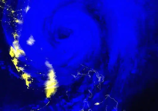
Black Marble Nighttime Blue/Yellow Composite
Summary
The Black Marble Nighttime Blue/Yellow Composite is a false-color visualization derived from nighttime observations collected by the Visible Infrared Imaging Radiometer Suite (VIIRS). The composite combines the VIIRS Day/Night Band (DNB) with the M15 longwave infrared band, with nighttime lights and other sources of emitted light generally appearing in shades of yellow and clouds appearing in shades of blue to yellow or white. The product provides a daily view of nighttime conditions that can help distinguish illuminated areas from cloud cover and identify changes in nighttime lighting following a disaster.
Suggested Use
The Black Marble Nighttime Blue/Yellow Composite can be used to identify nighttime lights and evaluate changes in illumination before and after disasters. Comparing cloud-free observations over time can help identify areas experiencing potential power outages and track restoration, particularly in rural, isolated, or off-grid communities where other outage information may be limited. The imagery can also highlight light emitted by wildfires, boats, and other nighttime sources. Because the product is based on at-sensor observations and is affected by cloud cover, lunar illumination, viewing conditions, and other factors, changes in brightness should be interpreted qualitatively and should not be used as the sole source of information for determining power outages.
Terms of Use
NASA data and products are freely available to federal, state, public, non-profit and commercial users. This information can be experimental- or research-grade data products and may not be appropriate for operational use. These NASA data products, services, and the Disasters Mapping Portal are intended to aid decision makers and enhance situational awareness, but these data are not guaranteed to be consistently available or routinely updated.
Satellite/Sensor
Visible Infrared Imaging Radiometer Suite (VIIRS) aboard the NASA/NOAA Suomi National Polar-orbiting Partnership (Suomi NPP) and NOAA-20 satellites
Resolution
Approximately 500 meters
Credits
NASA Goddard Space Flight Center (GSFC), NASA Earth Science Data and Information System (ESDIS), NASA Land, Atmosphere Near real-time Capability for EOS (LANCE), NOAA, and U.S. Naval Research Laboratory
Tags
NASA, VIIRS, Black Marble, Nighttime Lights, Blue/Yellow Composite, Day/Night Band, DNB, M15, Suomi NPP, NOAA-20, Power Outage, Disaster Response