
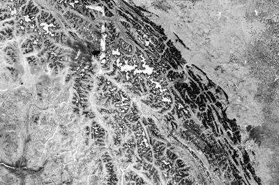
Landsat Normalized Burn Ratio (NBR)
Summary
Normalized Burn Ratio (NBR) is calculated using near-infrared and shortwave-infrared observations as (NIR - SWIR)/(NIR + SWIR). For Landsat 8 and Landsat 9, NBR is commonly calculated using Operational Land Imager (OLI) Band 5 for near-infrared and Band 7 for shortwave infrared. NBR is particularly sensitive to changes in healthy vegetation and charred or burned surfaces and is commonly used to assess areas affected by wildfire.
Suggested Use
Landsat NBR can be used to identify burned vegetation and assess spatial patterns of wildfire impacts. Healthy vegetation generally produces higher positive NBR values, while recently burned or charred vegetation generally produces lower or negative values. Comparing pre-fire and post-fire NBR observations can also be used to calculate differenced NBR (dNBR) for assessing relative burn severity.
Terms of Use
NASA data and products are freely available to federal, state, public, non-profit and commercial users. This information can be experimental- or research-grade data products and may not be appropriate for operational use. These NASA data products, services, and the Disasters Mapping Portal are intended to aid decision makers and enhance situational awareness, but these data are not guaranteed to be consistently available or routinely updated.
Satellite/Sensor
Operational Land Imager (OLI) and Operational Land Imager-2 (OLI-2) aboard the NASA/USGS Landsat 8 and Landsat 9 satellites
Resolution
30 meters
Credits
NASA, U.S. Geological Survey (USGS)
Tags
NASA, USGS, Landsat, Landsat 8, Landsat 9, OLI, OLI-2, NBR, Normalized Burn Ratio, Wildfire, Burned Vegetation